Understanding Tectonic Forces: Earthquakes, Volcanoes, and Staying Safe
Learn how tectonic plates drive earthquakes and volcanoes, and discover modern monitoring tools and community strategies to reduce risks and stay safe.
The Moving Crust: Plate Tectonics Basics
Earth's surface is constantly reshaped by tectonic plates—massive slabs of rock drifting a few centimeters each year. Their slow motion builds mountains, opens ocean basins, and triggers earthquakes and volcanic eruptions. The forces at work beneath our feet shape both the planet's geography and the hazards humans face. Understanding these processes is essential for designing safer buildings and preparing communities for inevitable natural events.
Plate Boundaries and How They Shape the Landscape
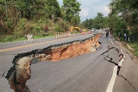
The lithosphere is cracked into about a dozen major plates that float on the semi‑fluid asthenosphere. These plates interact at three types of boundaries. At convergent boundaries, one plate slides under another (subduction), melting into magma that feeds explosive volcanoes. Divergent boundaries, such as mid‑ocean ridges, allow magma to rise and create new seafloor. Transform boundaries—like the San Andreas Fault—store friction that releases as earthquakes when stress builds up. Fault lines mark these fracture zones where blocks have moved past one another.
Monitoring Tectonic Activity with Advanced Technology
Scientists use a range of tools to track plate movement and predict hazards. Smartphone accelerometers produce real‑time shaking maps during quakes. Airborne geophysical surveys reveal hidden faults and rock layers. Satellites measure ground deformation to the millimeter using GPS and InSAR, showing where stress accumulates. Seismographs detect P‑, S‑, and surface waves, helping researchers locate epicenters and understand fault mechanics. These data streams feed models that improve hazard assessments and early‑warning systems.
Managing Risks from Earthquakes and Volcanoes
Volcanoes typically form above subduction zones, where water lowers the melting point of rock. Monitoring gas emissions, ground swelling, and small tremors helps forecast eruptions. For earthquakes, scientists study precursor signals such as changes in groundwater chemistry or foreshocks. While exact prediction remains impossible, dense sensor networks and satellite data make probabilistic forecasting more accurate. This knowledge leads to building codes requiring flexible, reinforced structures in seismic zones and guides evacuation plans for volcanic hazards.
Community Preparedness: The Key to Staying Safe
Public engagement is critical for reducing casualties. Smartphone‑based early warnings and citizen‑science projects turn millions of devices into a seismic network. School drills, education on drop‑cover‑hold, and retrofitting older buildings all save lives. Shared international databases help researchers refine global risk models. By combining geological understanding, technology, and community action, people can live safely in dynamic landscapes shaped by Earth's restless crust.