Comprehensive Guide to GPS and Navigation Technologies: How They Revolutionize Modern Travel and Location Services
This detailed article explores the evolution, functioning, and global significance of GPS and satellite navigation systems. From the origins of GPS to advancements in GNSS technology, it highlights how these systems revolutionize navigation, logistics, and modern transportation. The article also discusses future trends like autonomous vehicles and smart infrastructure, emphasizing the critical role of GPS in daily life and industry. An essential read for anyone interested in understanding the technology behind modern location-based services and how they are shaping the future of mobility and connectivity.

Understanding the Fundamentals of GPS and Modern Navigation Systems
Global Positioning System (GPS) technology has become an integral part of our daily lives, transforming the way we navigate, explore, and interact with our environment. This satellite-based system allows us to pinpoint precise locations anywhere on Earth with remarkable accuracy, facilitating everything from everyday smartphone navigation to complex military operations. In this comprehensive guide, we will delve into the origins, technological workings, and global advancements in GPS and satellite navigation systems, exploring their profound impact on various sectors, including transportation, logistics, emergency services, and beyond.
Defining GPS and Its Significance in Modern Navigation
GPS, or Global Positioning System, initially referred exclusively to the satellite navigation network developed by the United States Department of Defense. Over time, the term has expanded to encompass a broader array of satellite navigation systems collectively known as the Global Navigation Satellite System (GNSS). Today, GPS remains the most widely recognized and utilized system, but numerous other regional and global satellite constellations contribute to our navigational capabilities.
Originally designed for military applications, the GPS network was opened up for civilian and commercial use, dramatically expanding its influence and utility across various industries. This transition fostered innovations in personal navigation devices, logistics tracking, geolocation services, autonomous vehicles, and much more. The development of satellite navigation technology has revolutionized how both individuals and businesses operate in an increasingly connected world.
Evolution and Global Reach of Satellite Navigation Systems
While GPS remains the most prominent system, several other satellite networks operate globally or regionally, each complementing and enhancing positional accuracy and reliability. These include:
Russia's GLONASS
Europe's Galileo
China's BeiDou
India's IRNSS/NavIC
Each system is built with specific regional priorities in mind, offering unique features and levels of precision. Together, these systems form a robust network that ensures device accuracy and operational resilience for navigation and timing services worldwide.
US NAVSTAR GPS: The Pioneer Satellite Network
GPS consists of a constellation of 24 operational satellites orbiting approximately 20,200 kilometers above Earth. These satellites continually transmit real-time data, including their current positions and precise time signals, thanks to atomic clocks onboard. The signals enable ground-based receivers to triangulate their exact location by calculating the distance to multiple satellites simultaneously.
In the early days, GPS signals included an error correction code that limited accuracy—a safeguard against potential misuse. However, since the year 2000, this error correction was removed, significantly increasing the system's precision—down to a few meters—and paving the way for civilian, commercial, and scientific applications to thrive. This enhancement sparked global interest in developing alternative GNSS systems to achieve even greater accuracy and reliability.
Russia's GLONASS network also comprises approximately 24 satellites, providing similar global coverage and serving as a reliable alternative or complement to GPS, especially during Signal blockages or adverse weather conditions. Europe's Galileo system aims to deliver highly accurate positioning services, targeting commercial and civilian users, with the full constellation expected to operate at optimal capacity by 2019. China's BeiDou system, now with over 35 satellites, not only covers China but expands to international service, providing enhanced accuracy primarily for Chinese users. India's IRNSS (also called NavIC) is designed to offer enhanced navigation services within the Indian region, catering to both civilian and military needs, with encrypted signals ensuring security and precision.
How Satellite Navigation Works: The Science Behind Real-Time Location Determination
The core principle of satellite navigation relies on the continuous transmission of signals from satellites orbiting Earth. Ground-based receivers—whether in smartphones, vehicle dashboards, or specialized tracking devices—calculate their position by analyzing the time it takes for the satellite signals to reach them. This process is called trilateration, which requires signals from at least four satellites to accurately determine a user's three-dimensional position and synchronize their internal clock with the satellite clocks.
However, several factors can influence the accuracy of positioning data. These include orbital variations of satellites, atmospheric delays, multipath errors caused by signal reflections, and local terrain features. To mitigate inaccuracies, modern GPS systems incorporate augmentation techniques like Differential GPS (DGPS), Wide Area Augmentation System (WAAS), and local base stations. These enhancements improve positional accuracy, sometimes reaching centimeter-level precision.
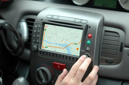
In practical applications, GPS data is integrated with digital maps, traffic information, and real-time updates such as route preferences, roadblocks, and dynamic traffic conditions. This synergy enables drivers, navigators, and logistics managers to optimize routes, avoid delays, and ensure timely deliveries. The proliferation of smartphones and connected devices has made GPS a ubiquitous tool for personal navigation, social location-based services, and emergency response systems.
As long as your device maintains connectivity with at least four satellites, it can reliably determine your location. This robust capability underpins the ease with which we navigate unfamiliar city streets, plan travel routes, or locate points of interest. Satellite navigation has transformed the concept of being lost into a thing of the past, offering peace of mind and operational efficiency across numerous industries.
The Future of GPS and Navigation Technologies
Advances in satellite technology continue to push the boundaries of precision, reliability, and integration. Emerging trends include the advent of next-generation GNSS systems that provide higher accuracy, resilience against interference, and better coverage in urban environments. The integration of GPS with other sensor technologies—such as inertial measurement units (IMUs), cameras, and lidar—is paving the way for autonomous vehicles, drones, and smart infrastructure.
Moreover, developments like Signal Encryption, Quantum Clocks, and enhanced augmentation systems will further strengthen the security and functionality of navigation networks. As the landscape of global positioning continues to evolve, it will play a critical role in shaping the future of smart cities, autonomous transportation, and global logistics networks.
In sum, GPS and satellite navigation technologies are foundational to modern life, fostering innovation and efficiency across countless sectors. Understanding their mechanisms, evolution, and future prospects offers valuable insights into how this technology continues to connect and guide us in an increasingly digital world.