Comprehensive Guide to How Satellite Navigation Systems Work
Satellite navigation systems, especially GPS, rely on a constellation of orbiting satellites and triangulation principles to determine precise user locations worldwide. This detailed guide explains how these systems work, from satellite orbit configurations to signal processing, emphasizing their critical role in navigation and related industries. Discover the science behind global positioning and how real-time data enables accurate navigation in diverse sectors.

Understanding the Inner Workings of Satellite Navigation Technology
Satellite navigation systems have become an integral part of modern life, enabling precise location tracking and navigation across the globe. To appreciate how these sophisticated systems operate, it's important to familiarize oneself with their foundational principles, components, and the science behind their accuracy. In this comprehensive guide, we will delve into the core mechanics of satellite navigation, with a focus on the widely used United States GPS network, which remains a benchmark in reliability and performance.
The cornerstone of global satellite navigation is the constellation of satellites orbiting the Earth. The Global Positioning System (GPS), operated by the United States, maintains a network comprising at least 24 active satellites. These satellites orbit at an altitude of approximately 20,200 kilometers (about 12,550 miles), completing roughly two laps around the Earth every 24 hours. The satellites are distributed in six orbital planes inclined at about 55 degrees, which ensures consistent coverage and visibility from virtually any point on the planet. The design guarantees that at any given time, at least four to six satellites are within view from an observer’s location, facilitating accurate positioning.
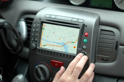
Understanding how satellite navigation determines your position involves exploring its three fundamental components: the space segment, ground control segment, and user equipment. The space segment consists of the satellites themselves, equipped with atomic clocks and signal transmitters. The ground control segment includes multiple monitoring and control stations responsible for maintaining satellite orbits and correcting timing errors. User equipment refers to GPS receivers found in smartphones, vehicle navigation systems, and various other devices designed to interpret signals and calculate precise locations.
Satellite navigation fundamentally operates through a process called triangulation, a technique with roots in traditional navigation methods that use landmarks, maps, and compasses. In essence, triangulation involves calculating a position based on the geometric intersections of signals from multiple sources.
Imagine someone lost in a vast wilderness, trying to determine their exact location. They can identify three distinct landmarks—say, a mountain, a river bend, and a flagpole—and measure the distances to each. The person’s position is found at the point where the circles centered on each landmark, with radii equal to those distances, intersect. This visual demonstrates the basic idea behind triangulation used in navigation systems.
Applying this concept to satellite navigation, a GPS receiver interacts with signals transmitted by at least three satellites. These satellites are positioned approximately 20,000 km away and continuously broadcast signals containing timing information. The receiver determines its distance from each satellite based on the time it takes for the signals, which travel at the speed of light (about 300,000 km per second), to arrive. The process involves measuring the time delay and translating it into a distance, considering factors like atmospheric interference that can affect signal speed. Accurate calculation of distances allows the receiver to determine its exact position through the intersection of three spheres, each centered on a satellite with a radius equal to the distance from the receiver.
To further improve precision, the system frequently uses four or more satellites—it accounts for the receiver's altitude and corrects potential errors in clock synchronization. These calculations happen almost instantaneously within the receiver, enabling real-time positioning and navigation. Additional correction systems, such as Differential GPS (DGPS), augment accuracy, especially for applications requiring extremely precise positioning like surveying or military operations.
In conclusion, satellite navigation systems leverage advanced space technology and precise calculations to provide accurate location information worldwide. Their reliance on orbital mechanics, triangulation techniques, and real-time data processing makes them indispensable tools in modern transportation, emergency response, agriculture, and countless other fields. As technology continues to evolve, future enhancements may include increased satellite constellations, integration with other global navigation satellite systems (GNSS), and improved signal processing, further increasing reliability and accuracy.